![](/images/other/stat-length.png)
![Trail Walking Les Vallées de la Vanne - Vareilles - Les Thorets - Photo](https://media.geolcdn.com/t/1900/400/ext.pjpeg?maxdim=2&url=https%3A%2F%2Fservices.sitytrail.com%2FGeolivesWS%2FDownloadMedia.ashx%3FTrailID%3D150185%26Media%3D02922737-c5ff-444f-a4d6-41ebc13620e2.jpg)
Vareilles - Les Thorets
Daneel-89
User
![Length](/images/other/stat-length.png)
Length
12.1 km
![Max alt](https://static1.geolcdn.com/siteimages/upload/files/1508320355ic_sort_altitude_max_24dp.png)
Max alt
220 m
![Uphill gradient](https://static1.geolcdn.com/siteimages/upload/files/1508320355ic_sort_den_pos_24dp.png)
Uphill gradient
235 m
![Km-Effort](/images/other/stat-length.png)
Km-Effort
15.2 km
![Min alt](https://static1.geolcdn.com/siteimages/upload/files/1508320355ic_sort_altitude_min_24dp.png)
Min alt
102 m
![Downhill gradient](https://static1.geolcdn.com/siteimages/upload/files/1508320355ic_sort_den_neg_24dp.png)
Downhill gradient
235 m
![Boucle](https://static1.geolcdn.com/siteimages/upload/files/16400158638029165_repeat_loop_refresh_sync_direction_icon.png)
Boucle
Yes
Creation date :
2014-12-10 00:00:00.0
Updated on :
2014-12-10 00:00:00.0
![Walking](https://static1.geolcdn.com/sitytour/trail-icons/101.png)
3h30
Difficulty : Medium
![Scan this QR Code to open this trail in the SityTrail application](https://capi.geolives.com/qq0zvz2zws4bq2lad0pu/sitytour/trails/150185/qr.png?size=200)
FREE GPS app for hiking
About
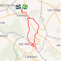
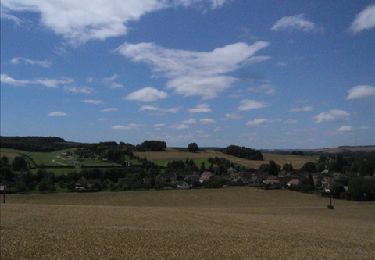
Trail Walking of 12.1 km to be discovered at Bourgogne-Franche-Comté, Yonne, Les Vallées de la Vanne. This trail is proposed by Daneel-89.
Description
Itinéraire :
Vareilles,
La Cote d'Enfer,
Les Thorets,
Les Vallées,
et retour sur Vareilles.
Difficulé(s) : Dénivelé
Curioisté(s) : Beaux points de vue
Positioning
Country:
France
Region :
Bourgogne-Franche-Comté
Department/Province :
Yonne
Municipality :
Les Vallées de la Vanne
Location:
Unknown
Start:(Dec)
Start:(UTM)
534929 ; 5336089 (31U) N.
Comments
Trails nearby
![Trail Walking Les Vallées de la Vanne - De bourg en hameaux - Vareilles - Photo](https://media.geolcdn.com/t/375/260/ext.jpg?maxdim=2&url=https%3A%2F%2Fservices.sitytrail.com%2FGeolivesWS%2FDownloadMedia.ashx%3FTrailID%3D191642%26Media%3D15289_5.jpg)
![Walking Walking](https://static1.geolcdn.com/sitytour/trail-icons/101.png)
De bourg en hameaux - Vareilles
Walking
Medium
Les Vallées de la Vanne,
Bourgogne-Franche-Comté,
Yonne,
France
![](/images/other/stat-length.png)
11.2 km | 14.6 km-effort
2h 45min
![](https://static1.geolcdn.com/siteimages/upload/files/16400158638029165_repeat_loop_refresh_sync_direction_icon.png)
Yes
![Trail Walking Les Vallées de la Vanne - Le bois du Champ-Fêtu - Vareilles - Photo](https://media.geolcdn.com/t/375/260/ext.jpg?maxdim=2&url=https%3A%2F%2Fservices.sitytrail.com%2FGeolivesWS%2FDownloadMedia.ashx%3FTrailID%3D191641%26Media%3D15288_1.jpg)
![Walking Walking](https://static1.geolcdn.com/sitytour/trail-icons/101.png)
Le bois du Champ-Fêtu - Vareilles
Walking
Medium
Les Vallées de la Vanne,
Bourgogne-Franche-Comté,
Yonne,
France
![](/images/other/stat-length.png)
12.8 km | 15.6 km-effort
3h 10min
![](https://static1.geolcdn.com/siteimages/upload/files/16400158638029165_repeat_loop_refresh_sync_direction_icon.png)
Yes
![Trail Walking Les Sièges - La pierre Colon - Les Sièges - Photo](https://media.geolcdn.com/t/375/260/ext.jpg?maxdim=2&url=https%3A%2F%2Fservices.sitytrail.com%2FGeolivesWS%2FDownloadMedia.ashx%3FTrailID%3D191640%26Media%3D15287_5.jpg)
![Walking Walking](https://static1.geolcdn.com/sitytour/trail-icons/101.png)
La pierre Colon - Les Sièges
Walking
Medium
Les Sièges,
Bourgogne-Franche-Comté,
Yonne,
France
![](/images/other/stat-length.png)
8.3 km | 10 km-effort
2h 15min
![](https://static1.geolcdn.com/siteimages/upload/files/16400158638029165_repeat_loop_refresh_sync_direction_icon.png)
Yes
![Trail Walking Les Vallées de la Vanne - A la découverte de Chigy et la Vallée de la Vanne - Photo](https://media.geolcdn.com/t/375/260/ext.jpg?maxdim=2&url=https%3A%2F%2Fservices.sitytrail.com%2FGeolivesWS%2FDownloadMedia.ashx%3FTrailID%3D111423%26Media%3D7216_4.jpg)
![Walking Walking](https://static1.geolcdn.com/sitytour/trail-icons/101.png)
A la découverte de Chigy et la Vallée de la Vanne
Walking
Medium
Les Vallées de la Vanne,
Bourgogne-Franche-Comté,
Yonne,
France
![](/images/other/stat-length.png)
7.3 km | 8.3 km-effort
1h 49min
![](https://static1.geolcdn.com/siteimages/upload/files/16400158638029165_repeat_loop_refresh_sync_direction_icon.png)
Yes
![Trail Walking Les Sièges - Hier et aujourd'hui... Promenade aux Sièges - Photo](https://media.geolcdn.com/t/375/260/ext.jpg?maxdim=2&url=https%3A%2F%2Fservices.sitytrail.com%2FGeolivesWS%2FDownloadMedia.ashx%3FTrailID%3D111239%26Media%3D6788_3.jpg)
![Walking Walking](https://static1.geolcdn.com/sitytour/trail-icons/101.png)
Hier et aujourd'hui... Promenade aux Sièges
Walking
Easy
Les Sièges,
Bourgogne-Franche-Comté,
Yonne,
France
![](/images/other/stat-length.png)
5.9 km | 7 km-effort
1h 30min
![](https://static1.geolcdn.com/siteimages/upload/files/16400158638029165_repeat_loop_refresh_sync_direction_icon.png)
Yes
![Trail Walking Les Vallées de la Vanne - Theil sur Vanne 230618 - Photo](https://media.geolcdn.com/t/375/260/ext.jpg?maxdim=2&url=https%3A%2F%2Fmedia.geolcdn.com%2Ff%2Ffa588dcd-1f8a-497b-803e-9cfe8dcc8e61.jpg)
![Walking Walking](https://static1.geolcdn.com/sitytour/trail-icons/101.png)
Theil sur Vanne 230618
Walking
Difficult
Les Vallées de la Vanne,
Bourgogne-Franche-Comté,
Yonne,
France
![](/images/other/stat-length.png)
10.1 km | 12.3 km-effort
2h 47min
![](https://static1.geolcdn.com/siteimages/upload/files/16400158638029165_repeat_loop_refresh_sync_direction_icon.png)
Yes
![Trail Walking Noé - Karine ( MICHEL ) - Photo](https://media.geolcdn.com/t/375/260/ext.jpg?maxdim=2&url=https%3A%2F%2Fmedia.geolcdn.com%2Ff%2F4275bdd6-58d5-4c2f-8a2b-b997023c34a1.jpg)
![Walking Walking](https://static1.geolcdn.com/sitytour/trail-icons/101.png)
Karine ( MICHEL )
Walking
Very difficult
Noé,
Bourgogne-Franche-Comté,
Yonne,
France
![](/images/other/stat-length.png)
23 km | 28 km-effort
6h 4min
![](https://static1.geolcdn.com/siteimages/upload/files/16400158638029165_repeat_loop_refresh_sync_direction_icon.png)
Yes
![Trail Walking Les Sièges - 210613 Les Sièges - Photo](https://media.geolcdn.com/t/375/260/ext.jpg?maxdim=2&url=https%3A%2F%2Fmedia.geolcdn.com%2Ff%2F64ba87df-9e12-4651-ba1c-320577889f64.jpg)
![Walking Walking](https://static1.geolcdn.com/sitytour/trail-icons/101.png)
210613 Les Sièges
Walking
Very easy
Les Sièges,
Bourgogne-Franche-Comté,
Yonne,
France
![](/images/other/stat-length.png)
10.8 km | 12.7 km-effort
3h 26min
![](https://static1.geolcdn.com/siteimages/upload/files/16400158638029165_repeat_loop_refresh_sync_direction_icon.png)
Yes
![Trail Walking Les Vallées de la Vanne - Vareilles - Les Thorets - La Cote d'Enfer - Le Fourneau - Photo](https://media.geolcdn.com/t/375/260/ext.jpg?maxdim=2&url=https%3A%2F%2Fservices.sitytrail.com%2FGeolivesWS%2FDownloadMedia.ashx%3FTrailID%3D151430%26Media%3Db89fd003-5bfc-42b3-807f-5cf5c097e2b4.jpg)
![Walking Walking](https://static1.geolcdn.com/sitytour/trail-icons/101.png)
Vareilles - Les Thorets - La Cote d'Enfer - Le Fourneau
Walking
Medium
Les Vallées de la Vanne,
Bourgogne-Franche-Comté,
Yonne,
France
![](/images/other/stat-length.png)
10.2 km | 13.6 km-effort
3h 0min
![](https://static1.geolcdn.com/siteimages/upload/files/16400158638029165_repeat_loop_refresh_sync_direction_icon.png)
Yes